General situation and characteristics of typhoon Poseidon
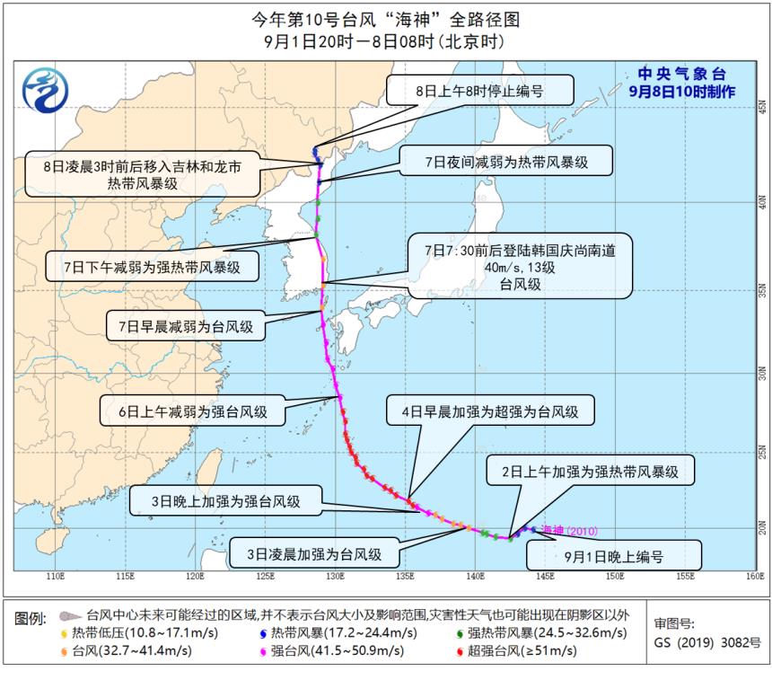
The 10th typhoon "Poseidon" this year (English name: Haishen;; Name source: China; Name meaning: the mythical god of the sea) was formed in the northwest Pacific Ocean on the night of September 1st, strengthened to a super typhoon level on the 4th, landed on the south coast of South Korea on the morning of the 7th (typhoon level, level 13, 40m/s), moved into helong city, Jilin Province, China in the early morning of the 8th (tropical storm level, level 8, 20m/s), and stopped numbering at 8 o’clock in Dunhua City, Jilin Province.
Typhoon Poseidon has the following characteristics:
Strong strength and stable path. At its strongest, Poseidon was a super typhoon, its maximum intensity reached 60m/s (level 17), and its intensity exceeded that of No.9 typhoon "Mesak" (at its strongest, it was 52m/s, level 16), making it the strongest typhoon in the northwest Pacific this year. After the formation of Poseidon, its northward path is similar to that of Typhoon No.9, and its landing point in South Korea and its entry into Jilin Province in China are very similar to that of Poseidon.
Life history is long, but it is only 5 hours in China. "Poseidon" came into being at 20: 00 on September 1st and stopped numbering in Jilin Province of China at 8: 00 on the 8th, with a life history of 156 hours, but its life history in China was only 5 hours. It moved into China when its intensity weakened to tropical storm level, and then it quickly weakened and degenerated into an extratropical cyclone.
Strong wind and rain, the affected area and "Mesak" overlap. Under the influence of Poseidon, the accumulated rainfall in central and eastern Heilongjiang, Jilin, eastern Liaoning and other places is 50 ~ 150 mm, and the rainfall at Huanhe Port in Hunchun City, Jilin Province is 168 mm, and Suifenhe River in Mudanjiang City, Heilongjiang Province is 152 mm; The rainfall of 14 national meteorological observatories exceeded the extreme value in September, and the daily rainfall of Suifenhe in Heilongjiang exceeded the historical extreme value. The above areas are accompanied by gusts of 8-9, with the maximum wind speed of 27.8m/s (Grade 10) in Dongning, Mudanjiang City, Heilongjiang Province and 24.6m/s (Grade 10) in Fangchuan Village, Hunchun City, Jilin Province. The area affected by wind and rain is highly overlapped with the area affected by Mesak.


It is rare in history that three typhoons in succession have affected Northeast China in the past half month.
In the past half month (from August 26th to September 8th), Northeast China was continuously affected by Typhoon Bawei No.8, Typhoon Mesak No.9 and Typhoon Poseidon No.10, which was the first time since meteorological records were recorded, and the number of typhoons affecting Northeast China was 1.8 more than that of the previous year (1.2). The common features of the three typhoons are as follows:
Life history is long, and there is concentration. Bawei, Mesak and Poseidon were all formed in the northwest Pacific Ocean, with their life histories of more than five days, among which Mesak has the longest life history of 168 hours (see attached table).
Strong intensity, all of which are typhoons landing northward. The intensity of the three typhoons increased first, and weakened before landing. At the peak of Bawei, the intensity was strong typhoon level, while Mesak and Poseidon reached super typhoon level. The paths of the three typhoons were stable, all of which landed northward. The landing intensity of Bawei and Poseidon was typhoon level, and that of Mesak was strong typhoon level.
After three typhoons moved into northeast China successively, they weakened and stopped compiling. After typhoon Bawei moved into Dandong, Liaoning, it continued to move northward into Jilin and then weakened and stopped editing; "Mesak" and "Poseidon" moved into helong city, Jilin Province, then moved westward into Heilongjiang Province, and gradually degenerated into an extratropical cyclone. Among them, "Mesak" stayed in Northeast China for the longest time, reaching 27 hours.
Three typhoons have brought strong wind and rain influence to Northeast China. During the influence of typhoons Bawei, Mesak and Poseidon, the average rainfall in Northeast China was 35 mm, 54 mm and 45 mm respectively. After moving into Northeast China, Bawei was dominated by gusts of 6-7, with local gusts of 8-10. "Mesak" is dominated by gusts of 8-10, with local gusts of 11-12; Poseidon is dominated by gusts of 8-9, with a local level of 10. Among them, "Mesak" has the strongest influence, and the daily rainfall of 49 national stations has exceeded the historical extreme in September. Generally speaking, Mesak is the strongest, Poseidon is the second, and Bawei is the weakest.

In the past half a month (from August 26th to September 8th), the average precipitation in Northeast China was 170.1mm, which was three times more than normal, and the highest since 1961. Among them, the precipitation in Heilongjiang Province and Jilin Province is 179.6 mm and 228.3 mm, respectively, which is 3-4 times more than the normal period, the highest in the historical period since 1961, and the precipitation in Liaoning Province is 106.5 mm, more than double the normal period, and the second highest in the historical period since 1961. Up to now, the precipitation in Northeast China (641.0mm) has been 27.4% higher than that in the same period of the previous year (503), which is the second highest in the same period since 1961.
Attached Table Statistical Comparative Analysis of Typhoon Bawei, Mesak and Poseidon

Future Typhoon Trends and Suggestions for Attention
It is expected that from September 10th to 15th, sunny weather will prevail in most parts of Northeast China, which is beneficial to agricultural production. In addition, it is estimated that there will be 3 ~ 4 typhoons in the South China Sea and the Pacific Northwest in the middle and late September, of which 1 ~ 2 may bring heavy wind and rain to the South China Sea. In autumn, the path and intensity of typhoons are changeable, and super typhoons are prone to occur. Therefore, the public should pay attention to the typhoon prevention work in time. The wind and rain brought by typhoon have a great impact, so it is necessary to guard against the adverse effects of typhoon wind and rain on agricultural production, fishery and coastal aquaculture, and the secondary disasters that may be caused by urban and rural waterlogging, flash floods, landslides and mudslides.
(Editor: Zhang Lin)