China Weather Network News The cold wave is coming! On December 12th, a strong cold air began to affect our country. Today, it will affect along the Yangtze River, and tomorrow it will reach Jiangnan and South China. Affected by this, the temperature in most parts of the country will hit a new low one after another until December 15th. Not only that, the large-scale rain and snow weather in the south will also be carried out on this "strong cold air train", and many cities may usher in snow at the beginning of this winter.
Strong winds and cooling will appear one after another, and the temperature in various places will be as low as "March 9" in a large area.
Yesterday, this strong cold air has begun to affect China, but it is still in the "starting" stage. The affected area is only in the plateau area, and most other areas are still in a relatively stable state, such as North China, Huanghuai, Jianghan and other places. Fog and haze still appeared in the morning, but at night, with the cold air killing, the visibility improved, and the gale cooling also officially appeared one after another.
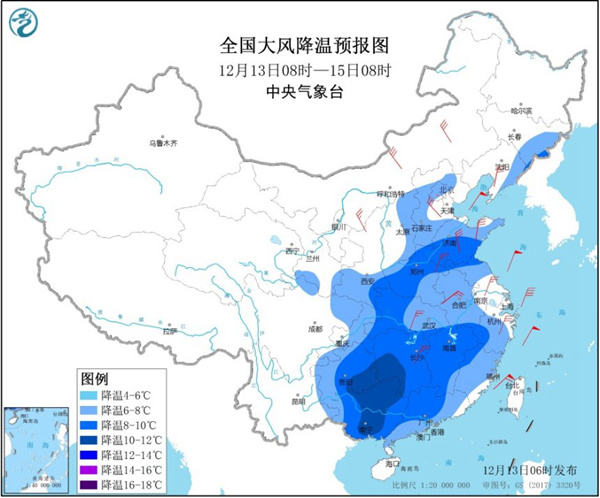
This morning, the Central Meteorological Observatory continued to issue a blue warning of cold wave. It is predicted that from 08: 00 on December 13th to 08: 00 on December 15th, the temperature will drop by 6 ~ 8℃ in the eastern part of Northeast China, southeastern part of Northwest China, most of North China, most of Huanghuai, most of Jianghuai, Jianghan, Jiangnan, eastern part of Southwest China and most of South China. Among them, the temperature will drop by 10℃ in some areas such as southwest Hunan, southeast Guizhou and central and northern Guangxi. After cooling, the minimum temperature line of 0℃ will be pressed south to the line from southern Guizhou to northwestern Zhejiang. There are 4 ~ 6 northerly winds with gusts of 7 ~ 8 in the north, 4 ~ 5 northerly winds in the south, 6 ~ 7 gusts in rivers and lakes, 6 ~ 8 northerly winds with gusts of 9 in offshore waters.
This cold air moves faster. It has arrived along the Yangtze River today and will "cross" the Yangtze River. Tomorrow, it will mainly affect Jiangnan and South China. Affected by this, the early high temperature pattern in all parts of the country will be completely broken and turned to be obviously low. Since it is a cold wave, the power of this strong cold air is not only that, of course. It will also cause the temperature in most parts of the country to hit a new low since beginning of winter, and let many areas experience the "March 9th" and "April 9th" cold in advance.
According to the forecast, the temperature in the northern region will hit a new low on the 13th to 14th. For example, in the northeast region, the highest temperature will generally drop to around -10℃, and the lowest temperature will drop all the way below -20℃. The highest temperature in the eastern part of northwest China, North China, Huanghuai and other places will drop to about 0℃, and the lowest temperature will only be around -10℃. In the southern region, the temperature will generally hit a new low on the 14th to 15th. In many places in Jianghuai, Jianghan and Jiangnan, it is only about 5℃ during the day, which can be called winter.
It is worth noting that after the end of this cold wave process, there will be another cold air impact from December 16 to 18. It is expected that the intensity will be weaker than the current one, but it will also make the temperature in most places continue to be low. In a word, the recent cold air is the rhythm of one after another. Everyone needs to pay attention to the approaching forecast, and it is the key to do a good job of cold protection and warmth.
There is little and weak snowfall in the north, and the rain and snow in the south are frozen on the line.
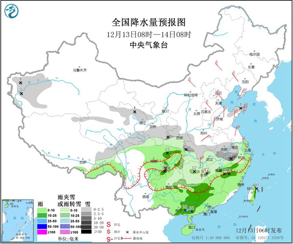
In terms of precipitation, the rain and snow brought by this strong cold air to the north is generally weak, mainly because there will be some rain and snow processes in the central and eastern regions; In the south, on the contrary, riding the "strong cold air train", rain and snow will spread out on a large scale. It is estimated that today, there will be small to medium snow or sleet in parts of the eastern part of the northwest, Jianghan, Jianghuai, western and northern Jiangnan, and eastern Guizhou, among which there will be heavy snow in southern Anhui and northwestern Hubei. There are small to moderate rains in parts of Sichuan Basin, most of Chongqing, western Guizhou, eastern Yunnan, southern Jiangnan, most of southern China and Taiwan Province Island, among which there is local heavy rain in southern Guangxi.
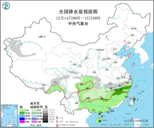
Tomorrow, the freezing situation of rain and snow in the southern region should not be underestimated. It is expected that there will be small to medium snow or sleet in parts of southwestern Xinjiang, eastern Tibet, southwestern Shaanxi, southern Hubei, western and northern Jiangnan, and northern and eastern Guizhou. There are small to moderate rains in parts of southeastern Tibet, eastern Southwest China, central and southern Jiangnan, and most of southern China, among which there is heavy rain in the northeast of Taiwan Province Island.
It is understood that the southernmost snow line of this precipitation process can reach the first line of southern Guizhou-southern Hunan-northwestern Jiangxi-northwestern Zhejiang. Many places including Wuhan and Changsha will begin to experience the process of rain-to-snow at night, such as Wuhan. It is possible to usher in snowfall this evening, but due to the high ground temperature, the snow will not be obvious. In addition, in Guizhou and the western part of Hunan, freezing rain may start from tonight and will continue until tomorrow. The wet and icy roads may greatly affect the morning peak next Monday.
Generally speaking, rain, snow and freezing at low temperature in Guizhou, Hubei, Hunan, Jiangxi and other places will lead to slippery roads, snow or icy roads. Public travel in these areas needs to pay attention to safety and arrange travel time reasonably.