CCTV News:According to the website of the Central Meteorological Observatory, the Central Meteorological Observatory continued to issue an orange rainstorm warning at 18: 00 on July 27.
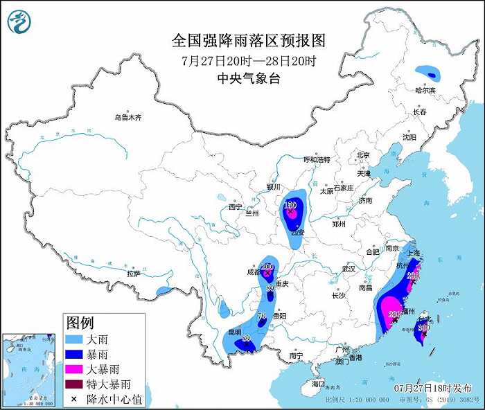
It is estimated that from 20: 00 on July 27 to 20: 00 on July 28, there will be heavy rain or heavy rain in eastern and southern Zhejiang, Fujian, most of Taiwan Province Island, and parts of southeastern Yunnan, western Guizhou, western Chongqing, eastern Sichuan, central Shaanxi and eastern Gansu. Among them, there are heavy rains (250-300 mm) in southeastern Fujian, southeastern Zhejiang and southeastern Taiwan Province Island. Some of the above areas are accompanied by short-term heavy rainfall (the maximum hourly rainfall is 30 ~ 60 mm, and the local area can exceed 80 mm), and there are strong convective weather such as thunderstorms and strong winds.
The Central Meteorological Observatory continued to issue a typhoon red warning at 18: 00 on July 27.
This year’s No.5 typhoon "DOKSURI" was upgraded from a strong typhoon to a super typhoon this afternoon (27th). At 5pm, its center is located in the northeast of the South China Sea, which is about 360 kilometers south-east of Xiamen, Fujian, that is, 21.4 degrees north latitude and 119.2 degrees east longitude. The maximum wind force near the center is 16 (52m/s), and the lowest pressure at the center is 935 hectopascals.
It is estimated that Du Surui will move to the north-west direction at a speed of 15-20 kilometers per hour, and its intensity will be strengthened. It will land in the coastal area from Dongshan to Putian in Fujian on the morning of the 28th (strong typhoon level or super typhoon level, 48-55 m/s, 15-16).
Gale forecast:From 20: 00 on the 27th to 20: 00 on the 28th, there will be strong winds of 5-7 and gusts of 8-9 in bashi channel, eastern and southern South China Sea, east Taiwan Province, Taiwan Province Strait, most of the East China Sea, Taiwan Province Island and its coastal areas, Fujian and its coastal areas, Zhejiang and its coastal areas, eastern Jiangxi, Jiangsu coastal areas, Shanghai and its coastal areas, and eastern Guangdong coastal areas. Among them, the winds in bashi channel, the sea area east of the northeast of the South China Sea, the sea area south of the Taiwan Province Strait, parts of southern Fujian and coastal areas and the southern coast of Taiwan Province Island can reach 8-12, and the gusts are 13-15. The winds in the nearby sea area where Du Surui Center passes can reach 13-16, and the gusts are 17 and above.
Precipitation forecast:From 20: 00 on the 27th to 20: 00 on the 28th, there were heavy rains or heavy rains in parts of eastern and southern Zhejiang, Fujian and most of Taiwan Province Island, among which there were heavy rains (250-300mm) in southeastern Fujian, southeastern Zhejiang and southeastern Taiwan Province Island.