On the morning of May 22nd, Guilin Meteorological Observatory of Guangxi Zhuang Autonomous Region released the first rainstorm red warning signal this year. Storm accompanied by thunderous thunder swept through the urban area of Guilin, and waterlogging occurred in many places. Cars driving on the road were like sailing.
Meteorological monitoring data show that the local three-hour precipitation in Xiufeng District of Guilin City is 300.1 mm, and the hourly rainfall intensity is 160.6 mm, which is comparable to the "July 20" torrential rain in Zhengzhou in 2021.
So, how strong is the rain in Guilin? What caused this extremely heavy precipitation? What impact has it brought to the local area? Tang Qiaoyi, director of Guilin Meteorological Observatory, made an interpretation.
1. How strong is the rain in Guilin?
A: The characteristics of short-term heavy precipitation in this process are obvious, the precipitation period is particularly concentrated, and the hourly rain intensity is particularly strong. From the early morning of the 22nd to the morning, there were heavy rains and torrential rains in Guilin, and local heavy rains and torrential rains. Lingchuan, Lingui, downtown Guilin, Yongfu and Gongcheng successively issued rainstorm red warning signal.
According to statistics, from 5: 00 to 8: 00 on May 22, the precipitation in three hours reached 300.1 mm, and the hourly rainfall intensity reached 160.6 mm, breaking the historical record of hourly rainfall intensity in downtown Guilin.
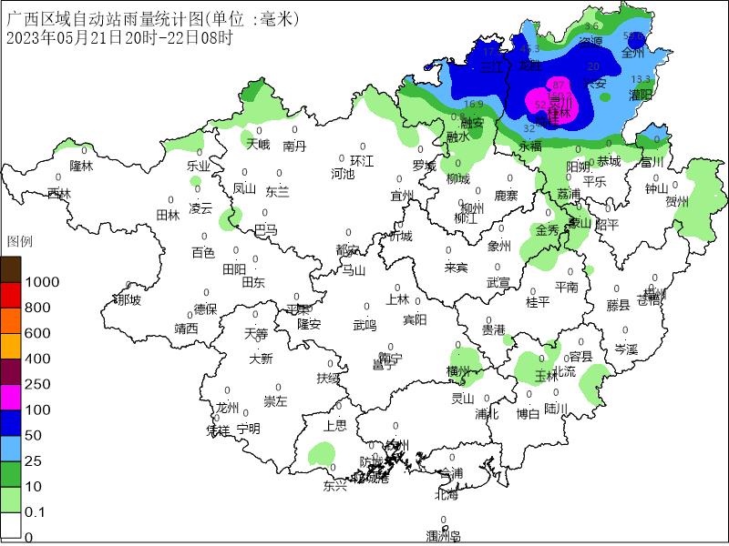
Compared with the "July 20" torrential rain in Zhengzhou in 2021, a rare continuous heavy precipitation weather process occurred in Zhengzhou from 18: 00 on July 18 to 0: 00 on July 21, 2021. The maximum hourly rainfall intensity exceeded 200 mm, and the cumulative average precipitation was 449 mm. It rained for nearly a whole year in previous years in three days (the average annual precipitation in Zhengzhou was about 600 mm).
The average annual precipitation in Guilin is between 1800 mm and 1900 mm. As far as the extreme precipitation process in Guilin is concerned, although the daily precipitation at individual stations reached the magnitude of torrential rain and broke the record of hourly rainfall intensity, the rain can flow away quickly because of the criss-crossing rivers and ditches in Guilin, and the precipitation process was mainly concentrated in the early morning to 10: 00, and then the rainfall intensity began to weaken and the urban waterlogging quickly receded, so the harm of this extreme precipitation process to Guilin was far less serious than that in Zhengzhou.
2. What caused this extremely heavy precipitation?
A: From the early morning of the 22nd to the morning, the extremely heavy precipitation weather in the north-central part of Guilin was mainly affected by the shear line, the low-level southwest jet and the weak cold air.
The shear line convergence is relatively strong, which provides dynamic conditions for heavy precipitation; The southwest jet in the lower level is strong, which provides unstable energy and sufficient water vapor source for heavy precipitation.
What is important is that during this process, the cold air in the north and the warm and humid jet in the southwest confronted each other in northern Guangxi, and the two sides were "unable to win or lose" for a while, which led to the slow movement of the weather system and the long stay of convective clouds in northern Guangxi, thus bringing about continuous heavy precipitation.
3. What is the impact of this extremely heavy precipitation?
A: This rain has a great impact on the urban area of Guilin. There has never been such a big extremely short-term heavy precipitation process in the urban area before. Affected by heavy precipitation, Guilin city was seriously waterlogged, traffic on some sections was interrupted, and local schools were suspended.
In response to this heavy precipitation process, the Guilin Meteorological Observatory released meteorological service information the day before, that is, on the morning of May 21st, to remind you to guard against this weather process. In the early morning of the 22nd, the duty room of Guilin Meteorological Observatory was busy, with the leaders in charge leading the way, and all business personnel on duty, paying close attention to the weather evolution trend. At 2: 05, a yellow warning signal for lightning was issued, a blue warning signal for gale was issued at 4: 17, an orange warning signal for rainstorm was issued at 4: 45, and the first rainstorm red warning signal this year was updated at 5: 32.
At 5: 55, according to the meteorological early warning and flood development trend of Guilin Meteorological Observatory, Guilin Flood Control and Drought Relief Headquarters launched Class IV emergency response to flood disaster. We made a phone call to the local party and government leaders’ mobile phones, to the duty room of the emergency bureau, and to every street office affected … … The latest forecast and early warning information is sent to the city, county, township and village levels through multiple channels at the first time, which provides support for flood control emergency command and dispatch, mass transfer organization and leadership decision-making.
Municipal Water Conservancy Bureau, Hydrological Center, Natural Resources Bureau, Urban Management Committee, Education Bureau, etc. all perform their duties and cooperate with each other. The local authorities strictly implemented the requirement of "everything must stop" and organized schools to suspend classes in time to avoid risks. According to the Guilin Evening News, as of 10: 00 on the 22nd, a total of 371 schools in downtown Guilin were closed, involving 139,813 students.
4. What will the local precipitation be like in the future?
A: At noon on the 22nd, the heavy precipitation clouds were far away from Guilin, and the impact on the urban area tended to end. Guilin Meteorological Observatory cancelled the orange rainstorm warning signal at 12: 51 on the 22nd and the yellow lightning warning signal at 14: 45.
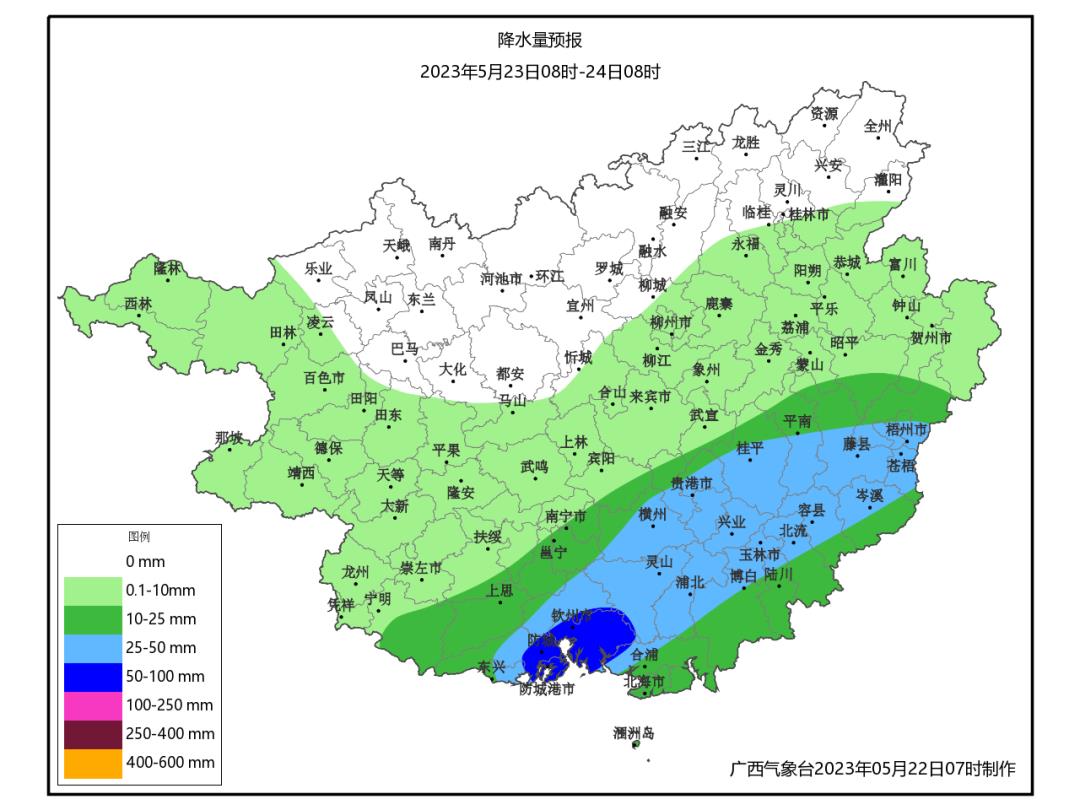
It is expected that the weather in Guilin will be mainly cloudy on the 23 rd; There was a shower on the 24th; There will be showers on the 25th, and there may be some heavy rain, but the precipitation intensity will not be as strong as this precipitation process on the 22nd.

Influenced by the underlying surface, the precipitation in Guilin is obviously localized, so it is necessary to pay attention to the floods in small and medium-sized rivers and urban waterlogging caused by local heavy precipitation in flood season. It is particularly important to note that there are many karst landforms in Guilin, and if precipitation is superimposed in the later period, there is a greater risk of disasters such as flash floods, mudslides and landslides.
The public should pay attention to prevent short-term heavy rainfall, thunderstorms, hail and other strong convective weather, and the power, transportation, tourism and other industries should guard against its adverse effects.